
Necessary, Problematic, and “Unusual”: Surface Water in the West Reserve
Jonathan Hildebrand
When reading through the history of Mennonites in Manitoba, it does not take long to encounter water. Historians writing about surface water and Mennonite settlement have pointed out the tendency of early villages to be laid out along creeks where possible,1 and the drainage efforts that began soon after the settlers’ arrival and continued throughout the ensuing decades.2 In addition to surface water, histories of Mennonites in Manitoba address the varied attempts to secure drinking water for growing settlements, and these efforts often make up portions of local village and town histories of the region. In the West Reserve particularly, the search for reliable sources of potable water informs local histories written on Altona, Gretna, Winkler, and Morden.3
The initial clustering of Manitoba Mennonites into two colonization reserves east and west of the Red River has also framed histories of Mennonites and water, particularly because of the different landscapes and environmental factors that characterize the two locations. The well-established environmental dichotomy within the Manitoba Mennonite story – that of the marshy, rocky East Reserve as less ideal for agriculture than the soils of the broad, flat West Reserve – perhaps makes it more difficult to see fully the detailed and fine-grained experiences of surface water in the West Reserve (although most writers do point out the lower, marshier conditions of its northern portions). The land on which the West Reserve was located became, of course, a fertile agricultural region, but an examination of archival documents, local histories, newspapers, and oral histories of West Reserve residents for mentions of surface water can enhance our understanding of it as a wet and variable area, in addition to productive farmland. Three themes in particular jump out in reviewing these sources from the years of Mennonite arrival to the postwar period: surface water as necessity, surface water as a problem, and surface-water environments as uniquely distinct – even “unusual” – within the prairie landscape.
As the West Reserve had no major rivers or lakes or sources of timber, nineteenth-century officials and settlement boosters knew that colonists would need access to water and wood beyond the boundaries of the reserve. Two main sources of timber for the initial settlers were the Pembina River to the south4 and the Pembina Hills to the west,5 although the Roseau River was also briefly considered by government officials in 1875,6 notably during a period when the Anishinaabeg there were vigorously protesting to the Department of Indian Affairs that other settlers had, for several years, been cutting wood on lands understood to be set aside for the Anishinaabeg.7 While it is unclear whether early West Reserve Mennonites utilized the Roseau for wood, government officials identifying it as a possible Mennonite timber source at a time when Indigenous peoples were advocating against the loss of trees speaks to a broader Canadian settler-colonial context into which Mennonites were “subtly and overtly incorporated.”8
In addition to wood, the availability of water was of concern to the settlers themselves, as John H. Warkentin has pointed out.9 Jacob Y. Shantz, the well-known facilitator of Mennonite migration to Manitoba, noted this in his March 1877 remarks to the House of Commons Standing Committee on Immigration and Colonization, stating that the immigrants objected to the location between the Red River and Pembina Hills because “there was scarcely enough hay land in that section for them.” However, “when they went on one side of it, they found a great big marsh, and that pleased them; there was hay land in this part.”10 Shantz was likely referring to the Buffalo Creek and Buffalo Lake area in the low northeast portion of the reserve, and although the very first Mennonite settlement locations weren’t immediately adjacent to this spot, they were nevertheless all within short distances to creeks or small hay lands. All nine of the Mennonite camps marked by Dominion Land Surveyor notebooks in the south-central portion of the reserve in 1875 were located next to a pond, small creek, or meadow area.11 Then, as the familiar single-street villages became established, many of those were also situated in close proximity to water resources as well. A comparison of the village locations noted in John Rempel and William Harms’s Atlas of Original Mennonite Villages, Homesteaders, and Some Burial Plots of the Mennonite West Reserve with surveyors’ notebooks showing the locations of creeks and marshes demonstrates that roughly twenty of the forty-five villages noted were located next to creeks or meadow areas.12
Scattered snippets from early settler memoirs indicate the importance of water in those early years. In recalling her childhood in the village of Altbergthal along Buffalo Creek in the late nineteenth century, Susanna Banman remarked, “We carried all the water from the creek.”13 Proximity to creeks and marshes was important not just for water, but for the construction of early rudimentary dwellings and structures. Jakob Fehr remembered that the roof of his family’s first dwelling was “covered with grass instead of straw. . . . Tall grass was growing along the creek [ritch] and the two sisters tied it into bundles for the roof.”14 Similarly, John A. Friesen’s recollection of settling in the Neuenburg area included a memory of their barn, the roof of which was “constructed of slough weeds or tall grass – or rye straw – at times gable and all.”15 In Dominion Land Surveyor notes, too, the countless cart trails crisscrossing the land were dutifully noted on survey plans, with one even marked “Hay Road,” highlighting the significance of those early transportation routes in relation to the resources provided by marshy areas.16
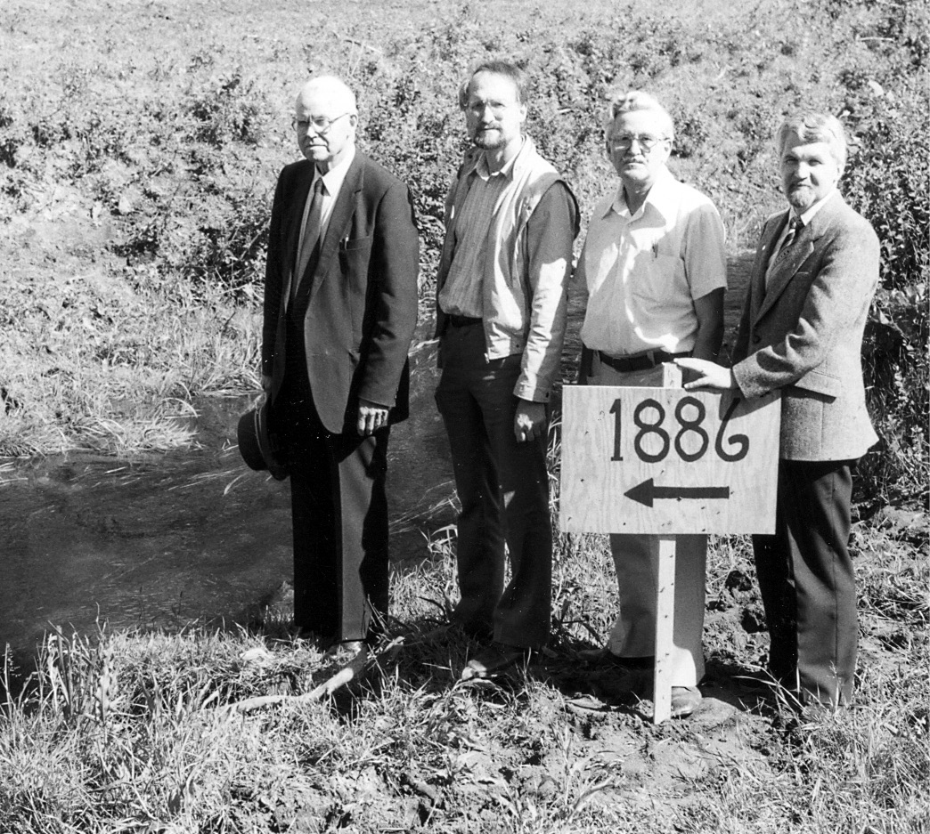
The connection between travel, topography, and water in the reserve is also evident in the transportation routes established by Indigenous peoples in the area long before the arrival of settlers. In the southern Manitoba prairie, away from the well-travelled banks of the Red and Assiniboine Rivers, trails typically “followed ridges and bypassed low areas,”17 and the “St. Joe Trail” – a Métis oxcart route connecting the nineteenth-century Métis hub of St. Joseph on the Pembina River in North Dakota (later named Walhalla) to Fort Garry (later Winnipeg) serves as an example of this.18 Part of an expansive network of cart trails that facilitated the dynamic mid-nineteenth-century borderland economy in which the Métis were key players,19 the trail crossed the forty-ninth parallel approximately six miles west of present-day Blumenort.20 In this low prairie it had very little elevated topography on which to be situated, along its southwest-to-northeast route through the West Reserve. Nevertheless it appears to have followed a slightly elevated contour for some distance, six to seven miles west of where Altona sits today21 and, as noted by Dominion Land Surveyors in 1875, closely followed the western and northern edge of Buffalo Lake, south of present-day Rosenfeld.22 By the 1880s, though, with settler agriculture the ascendant presence in the region, the trail had become a nuisance to farmers. When its location was surveyed in 1886 by the Dominion government at the request of the province as a potential permanent roadway,23 Mennonites in the region complained that “if it was intended as a road allowance . . . it is cutting up their farms into very inconvenient shapes running over them in a zig zag way.”24 Three years later, a Rural Municipality (RM) of Rhineland Council motion officially requested that “the Halfbreed trail from Morris to Walhalla . . . be closed,” as it “is no longer required.”25
Just as the old St. Joseph trail was a source of inconvenience for settlers, so, too, was the wetness that characterized portions of the West Reserve. Although creeks and marshes were necessary resources for initial Mennonite occupation, the flat “soup bowl” of southern Manitoba26 experienced seasonal flooding and contained fluctuating waterways and low areas, all of which “hindered agricultural prosperity on Mennonite lands.”27 For a “settler colonial model of export-oriented agriculture”28 to take its fullest shape, the lands needed to be better drained, particularly as settlement expanded more broadly through the reserve in the 1890s.29 As one source put it on the sixtieth anniversary of the RM of Rhineland in 1944 – echoing Governor General Lord Dufferin’s 1877 exhortation that East Reserve Mennonite settlers join “a war waged against the brute forces of nature”30 – the West Reserve region contained “only buffalo grass, swamps and mosquitoes” upon Mennonite arrival, and “drought, floods and all other forces of nature had to be overcome.”31
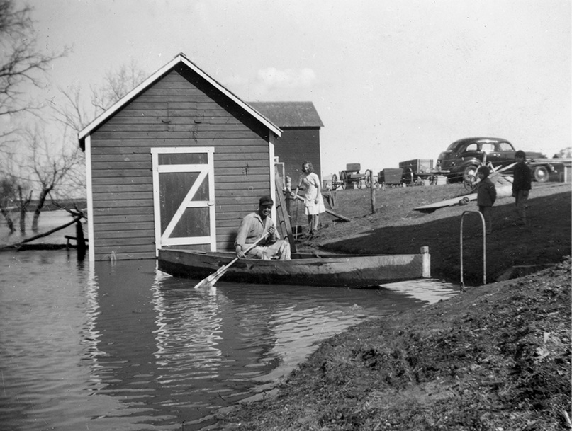
To do so required functioning within “the grid-based settlement pattern established by the federal government,” a system that was not aligned with existing hydrological patterns.32 As environmental historian Shannon Stunden Bower observes, the region’s moisture was highly variable and dynamic; “lands selected as dry did not always stay dry, and locations that provided ready access to wetland resources often proved vulnerable to flooding.”33 Some West Reserve Mennonites found this out in 1883, when Isaak Krahn, Heinrich Peters, and John Martens examined sections of in the northern part of the reserve, for which they had applied for homestead entry the previous August, “having never seen the said lands.” They found their quarter sections “to be covered with water to the depth of one foot or more, and totally unfit for cultivation.”34 A similar situation occurred in 1896, when another Mennonite applied to have his land purchase transferred to a different quarter section in the same township, “on account of the land he now holds being covered with water several inches deep.”35 Around a decade earlier, the entire village of Blumenfeld relocated from its initial location after “the runoff from the Pembina Hills came” and “nearly every house was flooded.”36
By the mid-twentieth century, anxieties around the springtime swelling of waterways were an annual feature of West Reserve life. Local newspaper reports on winter weather were often framed with an eye to spring, and when it eventually came, the social columns provided a weekly play-by-play on “torrents of water rushing eastward”37 from the Pembina Hills, “streets and ditches . . . filled with running water,”38 and washed-out roads.39 In the low land of the Rosenfeld area, periods of heavy rain could easily impact both seeding and harvest times. In April 1943, for example, the Altona Echo’s Rosenfeld correspondent reported that “seeding operations have begun” in “one of the earliest springs on record.”40 A little over one month later, that optimism had given way to reports of “excessive rains” that “dampened many farmers’ hopes for a good crop,” with “many fields . . . partly under water.”41 Days later, a week of sunshine brought positive declarations of “excellent” crop growth,”42 which, by mid-July, had evolved into reports of “badly lodged” and “partly flooded fields.”43
Spring and summer were not the only seasons in which rain could impact low-lying areas. In October of 1944, a farmer’s field was so muddy that one combine and two tractors got bogged down, and “the mosquitos attacked with such ferocity that the farmer in desperation lit part of the swathed field. The flames, however, became desperate and spread rapidly too,” so the workers then had a fire to put out before turning back to the task of dislodging the machinery.44
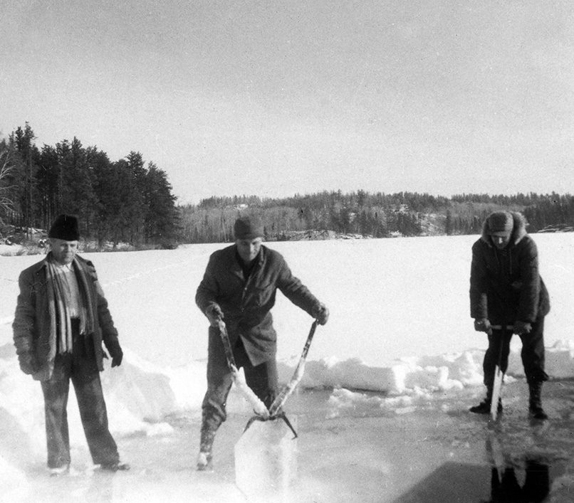
Continual efforts to remove water quickly from the land regularly proved insufficient as the development of the region increased. Throughout the 1960s and 1970s, drainage continued to be a dominant issue for the RM of Rhineland, with council meetings constantly discussing items such as “inadequate” culverts and ditches,45 ineffective drains,46 and requests to the provincial government for new dykes.47 However, while surface water was seen as problematic in some respects, the reserve’s creeks remained important resources for household needs during the postwar period. Historian Ruth Sandwell notes that up until 1940 Canada was a “rural majority” where “most rural homes,” including those on the Prairies, “lacked both electricity and running water.”48 This was certainly the case for some West Reserve farms even beyond the 1940s. Some households along Buffalo Creek would supplement their drinking water supply by cutting ice blocks from the creek to put into their cisterns,49 a practice that for one family who cut and sold ice to people in Altona was also an extra source of income.50 Creeks and low areas, then, were simultaneously agricultural problems and useful natural resources.
Combing the archives with an eye to water not only illuminates the environmental realities of the West Reserve; it also highlights the visceral experiences of living near creeks, deepening our historical awareness of water in a corner of the Prairies not always known for its waterways. Springtime especially created lasting childhood memories for those who grew up near creeks in the mid-twentieth century. The breakup of ice on Buffalo Creek could be “noisy,” with huge pieces of ice piled up and standing on end,51 and “when the water came” along the creeks south of Winkler, “you heard it; the sound . . . like a whoosh.”52 High water brought increased vehicle traffic to the creeks, as people came to see the extent of the flooding or, in some years, to watch dynamite being used to try to break up ice floes.53
Creek environments also produced distinct wildlife encounters from the early days of Mennonite settlement, with the Morden Monitor reporting in 1887 that a Mennonite farmer’s horse was attacked by either “a lynx or a wolf” in a pasture adjacent to “the scrub near the banks of the Dead Horse Creek.”54 Newspaper social columns sometimes made note of similar predator sightings into the twentieth century, as when the Echo reported that “bush wolves” had “moved down the [Pembina] mountain to invade the foothills,” having travelled “via the Derksen Coulees.”55 Descriptions of creek wildlife sometimes verged on the exotic: in the fall of 1945, a pelican shot by a farmer and “measuring nine feet between wing tips” was put “on display” in Rosenfeld, with “many people, including youngsters,” viewing it “with considerable interest – said interest being in the strange bill of the bird.”56 While fish were not overly common in these small waterways, high water in Buffalo Creek sometimes brought reports of fish being caught with “ordinary pitch forks” or by people “merely picking them out of the water with their hands.”57 If the creek spilled its banks in spring, reports occasionally came of farmers catching fish in the middle of their flooded fields,58 and wet conditions brought childhood opportunities for “crab digging” near creeks59 or in ditches, sometimes resulting in “enough to make a meal of them.”60
Within the generally flat character of the West Reserve’s landscape, the water, wooded areas, and wildlife of the creeks comprised distinct and unique environments, with opportunities for different experiences in all seasons. As the Echo remarked in the summer of 1947, “Buffalo Lake has an unusual attraction for outdoor lovers during these fine summer days. If it isn’t fishing and wiener roasts it’s boating. The latter was jolly fun for a group of seven local girls Tuesday morning.”61 The opportunity for a more “unusual” recreational environment within a prairie agricultural setting commonly drew people to the creeks and the nearby Pembina River62 for school, youth, and Sunday school events, as well as church events such as baptisms. The first Mennonite Brethren baptism in the West Reserve was held in May of 1886 “near Burwalde in the Dead Horse Creek,” and in subsequent decades baptisms in the Gnadenthal Mennonite Brethren Church “were usually held in the little creek running between Gnadenthal and the Blumengart Colony.”63
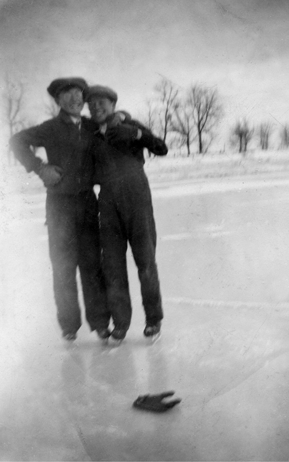
Fruit and other plants grew along many waterways in the summertime, including along the Marais River where “saskatoons and plums and chokecherries – at least three different cherries” – all flourished, along with hops that were “use[d] to make bread.”64 And if the water froze just right in winter, children would sometimes have a skating rink “two miles, three miles long” on the Marais,65 or could “skate for a mile or two . . . to the neighbours’” along Buffalo Creek.66 The “unusual attraction” of creeks could also imbue those living near them with a sense of place and identity somewhat different than those of people in the West Reserve who did not grow up near water, as evidenced in childhood recollections from the 1960s and 1970s. Feelings of distinctiveness in being “woodlot people,” memories of creeks and forested areas as magnets for cousins and friends to come play, the sense that there was some “kind of importance to being able to grow up along the creek,” and even remembering childhood friends who didn’t live near water and who could not fully understand how water and ice behaved during flood season all show the impacts these environments had.67
In the context of the West Reserve, considering how “history look[s] when we begin with water”68 can deepen our understanding of an environment that has sometimes been referred to as “barren.”69 It can point to connections between settlement and water, Indigenous land uses and transportation, evolving settler interactions with the wet prairie, and the unique personal experiences of creek environments. That Mennonites have experienced the West Reserve’s water and landscape in such varied ways speaks to the layered and complex nature of the region itself – it is agriculturally fertile, it is an Indigenous homeland, it remains part of a dynamic wet prairie, and it has always been a place where the small ribbons of water and broad low areas are integral components of both the landscape and people’s experience of it.
Jonathan Hildebrand is a PhD candidate in History at the University of Manitoba. Originally from Altona, Manitoba, he resides in Winnipeg and has lived most of life in Treaty 1 Territory.
- E. K. Francis, In Search of Utopia: The Mennonites in Manitoba (Glencoe, IL: The Free Press, 1955), 67; Gerhard Ens, Volost and Municipality: The Rural Municipality of Rhineland, 1884–1984 (Altona, MB: R.M. of Rhineland, 1984), 27. ↩︎
- John H. Warkentin, The Mennonite Settlements of Southern Manitoba (Steinbach, MB: Hanover Steinbach Historical Society, 2000), 189–198; Ens, Volost and Municipality, 74, 96–99, 208–11, 235–37. ↩︎
- Esther Epp-Tiessen, Altona: The Story of a Prairie Town (Altona, MB: D. W. Friesen & Sons, 1982), 69, 158, 269–73; F. G. Enns, Gretna: Window on the Northwest (Gretna, MB: Village of Gretna History Committee, 1987), 40–41, 85, 275–77; Frank Brown, A History of the Town of Winkler, Manitoba (Winkler, MB: self-pub., 1973), 87; Morden Centennial Committee, Morden, Mort Cheval, Pinancewaywinning, Lake Agassiz (Morden, MB: Morden Centennial Committee, 1981), 5–6, 13. ↩︎
- Bruce Wiebe, “The Timberlots of the Manitoba Mennonites in St. Joseph Township, Pembina County, Dakota Territory,” Preservings, no. 27 (2007): 47–52. ↩︎
- Irene Friesen Petkau and Peter A. Petkau, Blumenfeld: Where Land and People Meet (Winkler, MB: Blumenfeld Historical Committee, 1981), 215; Peter D. Zacharias, Reinland: An Experience in Community (Altona, MB: Reinland Centennial Committee, 1976), 44. ↩︎
- Donald Codd to J.S. Dennis, telegram, July 23, 1875, RG15-D-II-1, vol. 232, file 3129, part 1, microfilm T-12180, Library and Archives Canada (LAC), Ottawa. ↩︎
- “Report of Interview between the Honourable the Minister of the Interior, and Certain Indians Residing on the Reserve at Roseau River, at Winnipeg, October 1st, 1875,” RG10, vol. 3598, file 1447, microfilm C-10104, LAC. ↩︎
- Reina C. Neufeldt, “Settler Colonial Conscripts: Mennonite Reserves and the Enfolding of Implicated Subjects,” Postcolonial Studies 25, no. 4 (2022): 510. ↩︎
- Warkentin, Mennonite Settlements, 33. ↩︎
- Appendix to the Eleventh Volume of the Journals of the House of Commons, 3rd Parl., 4th Sess., app. 6, 111. ↩︎
- “Survey Notebook #584: Township 1 Range 3W,” 1875, Land Surveyors Field Books, NR 0157, GR1601, G 14349, Archives of Manitoba (AM), Winnipeg; “Survey Notebook #585: Township 1 Range 4W,” 1875, Land Surveyors Field Books, NR 0157, GR1601, G 14349, AM. ↩︎
- Twenty is an approximate number, and it is probable that there were more villages near water. Since surveyors typically only made note of what they saw along the road allowance lines on the borders of quarter sections, any marshy areas or sections of creeks in the middle of a quarter section could be missed, and therefore would not appear in the survey notes. Thus, a village that doesn’t appear to have been next to water may actually have been, if it was a body of water that a surveyor missed. John Rempel and William Harms, Atlas of Original Mennonite Villages, Homesteaders, and Some Burial Plots of the Mennonite West Reserve (Altona, MB: self-pub., 1990); “Survey Notebook #584”; “Survey Notebook #585.” ↩︎
- “Mother’s Writings [Susanna Banman] Translated by Her Daughter Susana,” 1966, Jake Peters Sommerfeld Mennonite Church Collection, vol. 5267, file 27, MHA. ↩︎
- “Jakob Fehr (1859–1952) Journal as Translated and Published in Peter Zacharias, Reinland: An Experience in Community, 1976,” Jakob Fehr Fonds, vol. 4891, file 5, MHA. ↩︎
- Jacob Friesen Collection,document 2, n.d., Jake Peters Sommerfeld Mennonite Church Collection, vol. 5267, file 21, MHA. ↩︎
- “Survey Notebook #584.” ↩︎
- Shannon Stunden Bower, Wet Prairie: People, Land, and Water in Agricultural Manitoba (Vancouver: UBC Press, 2011), 22. ↩︎
- Leonard Doell, “Walhalla Trail” (student paper, Canadian Mennonite Bible College, 1978), Conference of Mennonites in Canada Fonds, Native Ministries Series, vol. 4998, file 26, MHA. ↩︎
- Michel Hogue, Metis and the Medicine Line: Creating a Border and Dividing a People (Regina: University of Regina Press, 2015), 48–51. ↩︎
- “Map,” n.d., Administrative Files Including Correspondence and Reports Regarding Land Survey of Manitoba, NR 004, GR0289, G 402, AM. Manitoba has two communities named Blumenort, one near Steinbach, in the former East Reserve, and the Blumenort referenced here, known officially as Blumenort South, located in the former West Reserve. ↩︎
- “Map”; “Emerson Sectional Map 23,” 1922, University of Manitoba Archives and Special Collections, https://www.flickr.com/photos/manitobamaps/3681736953/in/album-72157622868092934/. ↩︎
- “Survey Notebook #583: Township 1 Range 2W,” 1875, Land Surveyors Field Books, NR 0157, GR1601, G 14349, AM. ↩︎
- “Order in Council Re: Trails to Be Surveyed,” n.d., Highways Branch Office Files, A 0045, GR1618, G 833, AM. ↩︎
- E. Winkler to Surveyor General, Nov. 25, 1886, Administrative Files Including Correspondence and Reports Regarding Land Survey of Manitoba, NR 0004, GR 0289, G 402, AM. ↩︎
- Minutes of Special Council Meeting, Nov. 19, 1889, Records of Municipality of Rhineland, and of Douglas: Minutes of Council Meetings (1884–1925 and 1884–1891), microfilm 381, MHA. ↩︎
- Stunden Bower, Wet Prairie, 2. ↩︎
- Stunden Bower, Wet Prairie, 38. ↩︎
- Shelisa Klassen, “Land, Sovereignty, and Migration During an Era of Change: Manitoba, 1870s” (PhD diss., University of Manitoba, 2022), 160. ↩︎
- Ens, Volost and Municipality, 57. ↩︎
- “The Viceregal Visit: The Trip to the Mennonites,” Manitoba Free Press, Aug. 25, 1877. ↩︎
- H. H. Hamm, Sixty Years of Progress, 1884–1944: The Rural Municipality of Rhineland (Altona, MB: D.W. Friesen & Sons, 1944), 10. ↩︎
- Stunden Bower, Wet Prairie, 38. ↩︎
- Stunden Bower, Wet Prairie, 25. ↩︎
- Letter to Surveyor General, June 9, 1883, Digitized West Reserve Homestead Files, MHA. The lands were located in township 3-2W. ↩︎
- Secretary, Department of the Interior, to D. Stewart, Rosenfeld, May 30, 1896, Federal Department of the Interior Homestead Files, NR 0215, GR2060, microfilm 2182, AM. The original quarter section was located in township 3-1W. ↩︎
- Friesen Petkau and Petkau, Blumenfeld, 1. ↩︎
- “Rosenfeld,” Altona Echo, Apr. 12, 1944. ↩︎
- “Winkler,” Altona Echo, Mar. 14, 1945. ↩︎
- “Plum Coulee,” Altona Echo, Apr. 8, 1942. ↩︎
- “Rosenfeld,” Altona Echo, Apr. 14, 1943. ↩︎
- “Rosenfeld,” Altona Echo, June 9, 1943. ↩︎
- “Rosenfeld,” Altona Echo, June 20, 1943. ↩︎
- “Rosenfeld,” Altona Echo, July 14, 1943. ↩︎
- “Rosenfeld,” Altona Echo, Oct. 11, 1943. ↩︎
- Minutes of the Rural Municipality of Rhineland Council, Feb. 2, 1960, Records of Rural Municipality of Rhineland: Minutes of Council Meetings (1926–1965), microfilm 382, MHA. ↩︎
- Minutes of the Rural Municipality of Rhineland Council, June 6, 1960, Records of Rural Municipality of Rhineland: Minutes of Council Meetings (1926–1965), microfilm 382, MHA. ↩︎
- Minutes of the Rural Municipality of Rhineland Council, Oct. 10, 1972, Records of Rural Municipality of Rhineland, and of Douglas: Minutes of Council Meetings (1965–75), By-laws (1–699), and (1–41), microfilm 383, MHA. ↩︎
- R. W. Sandwell, Canada’s Rural Majority: Households, Environments, and Economies (Toronto: University of Toronto Press, 2016), 8. ↩︎
- Martha Martens, interview by the author, Nov. 16, 2023; Glenda Hildebrand, interview by the author, Apr. 29, 2024; Gary Klassen, interview by the author, May 6, 2024. ↩︎
- Martens, interview. ↩︎
- Martens, interview. ↩︎
- Marilyn Elias, interview by the author, Jan. 27, 2024. ↩︎
- Interview with West Reserve resident, Mar. 20, 2024; Hildebrand, interview. ↩︎
- “Town and Country,” Morden Monitor, July 14, 1887. ↩︎
- “Pembina Mountain Murmurs,” Altona Echo, Mar. 19, 1947. ↩︎
- “Rosenfeld,” Altona Echo, Oct. 3, 1945. ↩︎
- “Good Fishing at Schoenthal,” Altona Echo, June 18, 1947. ↩︎
- “Cloudburst and Spring Thaw Floods Inundate Countryside,” Altona Echo, Mar. 28, 1945; “Another True Fish Story,” Altona Echo, May 9, 1945. ↩︎
- Zacharias, Reinland, 284. ↩︎
- Cleo Heinrichs, ed., Horndean Heritage (Winkler, MB: Horndean Reunion Committee, 1984), 27. ↩︎
- “What’s Happening Around Town,” Altona Echo, July 2, 1947. ↩︎
- “What’s Happening Around Town”; “Winkler,” Altona Echo, July 30, 1941. ↩︎
- Elisabeth Peters, ed., Gnadenthal, 1880–1980 (Winkler, MB: Gnadenthal History Book Committee, 1982), 86, 68. ↩︎
- Bill Schroeder, interview by the author, Nov. 20, 2023. ↩︎
- Schroeder, interview. ↩︎
- Hildebrand, interview. ↩︎
- Richard Warkentin, interview by the author, Jan. 20, 2024; Elias, interview; Hildebrand, interview; Klassen, interview. ↩︎
- Adele Perry, “Presidential Address. Starting with Water: Canada, Colonialism, and History at 2019,” Journal of the Canadian Historical Association 30, no. 1 (2019): 7. ↩︎
- Peters, Gnadenthal, 28; Enns, Gretna, 52. ↩︎